
By Natasha Julius
Governor Pat Quinn’s blue-ribbon commission on transit reform is due to issue its first report by Friday. This week we’re presenting four recommendations of our own that just might fix this mess.
–
Suggestion #1: Kill Metra.
Suggestion #2: Look At A Fucking Map.
–
Suggestion #3: Invest In What’s Already Here.
There is a set of train tracks running in front of the Cook County Court building along 26th. Remnants of an elevated embankment cut across the city’s midsection south of Pershing. In Chicago and the near suburbs, abandoned rail lines form an elaborate web of disintegrating infrastructure all around us. The potential of these resources to galvanize our transportation system is enormous; wherever possible, they should be given over for public use.
The reclamation of rail rights-of-way is not a new idea. The CTA’s Orange Line and Metra’s North Central were built using existing freight tracks. Planned extensions of the Orange, Red and Yellow lines would use similar strategies. Existing corridors within the city could alleviate the paucity of decentralized connections. They could add tremendous capacity to our mass transit systems without diminishing capacity on surface roads.
Determining which existing lines are eligible for redevelopment is a daunting task. Often abandoned tracks are mixed in with others that are still in use. Trying to sort out which tracks are owned by whom quickly leads you into a black hole of railroad consolidation history. The suggestions given below involve only rights-of-way that have been acknowledged as abandoned in the public record, or those that show visible signs of advanced deterioration. There may be many more; all should be pursued.
The Mid-City Transitway
Running north-south along Kenton Avenue for much of the length of the city, this abandoned branch of the Chicago Belt Railway was for many years associated with one of the more infamous transportation plans in recent memory: the Crosstown Expressway. In the 1960s, the Crosstown was proposed as a bypass route, an alternative to the Dan Ryan that avoided downtown traffic. The only trouble was the eight-lane expressway would’ve required the destruction of some 30,000 homes in countless neighborhoods. (Click here for a map of the proposed Crosstown route.) With the wounds of the Dan Ryan construction still bleeding, the people of Chicago rose up and handed Richard the First a rare defeat.
Since the Crosstown was cancelled in 1979, the available embankment has not been redeveloped. It popped up in the City’s plans as recently as 2007, when Richard the Second commissioned a study to determine the feasibility of several alternatives including a new L line and a truck bypass. To date, nothing has been done to move this corridor closer to public use.
The Mid-City is unique among available rights of way for its sheer length. Few other rail lines extend as far north, and none are as poker-straight. The location of the line, just east of Cicero Avenue, makes connecting with existing CTA and Metra lines much easier – many of these lines have Cicero stations that could be linked. The Mid-City would also offer access to both Midway and O’Hare.
While the proposed layout of the Mid-City extends as far north as the Blue Line at Montrose, an adjacent abandoned right-of-way could carry the Mid-City all the way up to the Yellow Line, giving north suburban residents a new mass transit route to Chicago’s airports.
View Mid-city Transitway Northern Extension in a larger map
The limiting factor of the Mid-City is the width of the available embankment, thought to be somewhere between 50 and 70 feet. Even if it is as narrow as 50 feet, it would allow ample room for a true Bus Rapid Transit line. If the embankment permits, this could be combined with a recreational path that could serve as a bookend with the Lakefront Path. This type of redevelopment could make the Mid-City a welcome addition to the surrounding communities.
Please note, the original Crosstown Expressway plan called for the road to make a sharp left turn at 75th Street and connect with the Dan Ryan. The existing rail corridor along 75th is still in use (including, in portions, by Metra). As such, it may not be possible to extend a BRT line along that portion.
The Campbell Corridor
The tracks that run along 26th Street in Little Village are leftover from a complex distribution system that once operated along the Chicago River. Many of these shorter spurs fed into a north-south rail artery located half a block west of Western Avenue. At its northern end, the line merges with freight and Metra tracks close to Fulton. To the south, it joins a massive freight route that runs all the way to Blue Island. Part of this right-of-way is used by the Orange Line, from Pershing to roughly 49th Street.
View Abandoned right of way along Campbell in a larger map
A new CTA line using this corridor would link Metra’s Milwaukee District Line with the CTA’s Green (Lake Street Branch) Blue, Pink and Orange Lines. Moving the current California Green Line Station a couple of blocks east could spur the creation of a new mini-hub. The line would serve the aforementioned Cook County Court building, as well as Douglas Park and the new wall-to-wall IB high school in Back of the Yards. It would link communities that are currently divided by the river and the Eisenhower and Stevenson expressways.
At around 55th it becomes unclear whether any of the existing tracks have been abandoned. If, however, an available right-of-way extends as far south as 63rd it would make the dream of a Circle Line feasible. The freight lines along Western pass tantalizingly close to the current terminus of the Green Line at 63rd and Ashland.
The Stockyards and Kenwood Lines
As previously noted, Chicago’s bike path system has grown considerably in recent years. Some parts of the city, however, remain stubbornly unfriendly to cyclists. One such fallow patch stretches from 33rd Street to 47th and from Halsted to King Drive. It encompasses parts of Bronzeville and Bridgeport, as well as US Cellular Field. In the middle of this expanse runs an embankment that used to hold the Kenwood and Stock Yards branches of the South Side Elevated.
View Kenwood and Stock Yards Embankment in a larger map
Both of these branches were abandoned in the 1950s. The surviving infrastructure is riddled with problems. Most of the bridges east of the Dan Ryan were removed, so the lines are not contiguous. West of Stewart, the right-of-way broadens and it’s unclear which tracks (if any) are in use. The area is heavily industrial, so it’s entirely possible this track system is still in use from freight.
All of this said, the two abandoned spurs offer the potential for a recreational path and park system that could put the 606 to shame. The Kenwood embankment is now lushly forested, creating a unique natural environment. It offers easy access to the Lakefront Path via Oakwood and crosses a major north-south bike lane route at King Drive. A trail-to-rail hub at Indiana would give easy access to IIT and the Loop. The line traverses Stateway Park, where a spur turns north toward Bronzeville. The suggested western terminus at Halsted is close to the historic Union Stock Yard gate at Exchange and Peoria. There is a line of track that runs right by the gate, although it’s again unclear whether this is in use.
This project would be massive. It would also be unprecedented in its capacity to link disparate communities. This is an area that was torn apart by the construction of the Dan Ryan; a recreational path like this would be a refreshing and innovative way to reconnect former neighbors.
Right now, Chicago is an elaborate tomb for the once-dominant railroad industry. Unused tracks and abandoned embankments litter neighborhoods throughout the region. It’s time to resurrect these features in service of the people who live here.
–
Next: Put The Public In Public Transit.
–
Comments welcome.
–
1. From Carl Giometti:
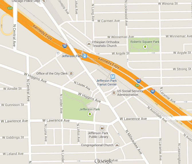
Great series of articles. However, I was surprised to see Jefferson Park left off the list. This always seemed the most natural location to me for building a large transit hub and up-zoning the surrounding land.
 (ENLARGE)
–
Natasha replies: Jefferson Park pops up as a possible terminus for the Mid-City in some of the more recent reporting. It has tremendous potential to open up transit to the far northwest corner of the city. Great suggestion and I welcome any others!
Posted on October 16, 2013